
About this Region - Place
Location
East: 153° 17" 17´, South 28° 53" 58´ (Mt Warning).
Spanning the New South Wales and Queensland state borders, the area is located in the far north eastern corner of the state of New South Wales (NSW), with the state of Queensland (QLD) immediately to the north.
The region is often referred to relative to its location within the state of NSW as "the far north coast", "Northern Rivers" or simply "the North Coast".
The Queensland side of the border maybe referred to as "the Gold Coast", "Gold Coast hinterland" or "south east Queensland", which is often used in weather and government references, but less frequently in daily use.
The Southern Gold Coast (QLD) suburb of Coolangatta, and Tweed Valley (NSW) town of Tweed Heads are often referred to as the "Twin Towns". At Point Danger you can stand astride the state border and during Summer, enjoy a one hour time warp, thanks to the observance in NSW (and lack in QLD), of daylight saving time.
The region is easy to get to and well served by plane, road and train services.
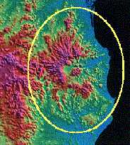
Regional satellite image © courtesy of GeoScience Australia
Climate
The region is popular with visitors for it's comfortable year round subtropical climate, with more than 250 days of sunshine each year on average.
The CSIRO in Canberra has indicated that Northern NSW has the most ambient climate in Australia, and we locals agree.
The following is a good general guide:
- Summer (December - February): Warm nights with warm to hot days, afternoon rain or thunderstorms common; Air temp. 20° to 30° C (67° to 87° F) Water temp. 26° C
- Autumn (March - May): Generally warm, some rain showers; Air temp. 15° to 25° C (57° to 77° F) Water temp. 23° C
- Winter (June - August): Cool to cold nights with warm sunny days; Air temp. 5° to 20° C (41° to 67° F) Water temp. 21° C
- Spring (September - November): Cool to warm nights with warm (occasionally hot) days, isolated showers; Air temp. 12° to 22° C (51° to 71° F) Water temp. 22° C
(15/07/18, Please note: The above averages are from 1990 (see References below). As of January 2018 the annual national mean temperature is 0.95C above average, while the maximum and minimum temperatures for 2017 were warmer than average, up to 1.27 °C above average.)
The daily sunshine average ranges from 6.5 hours during July (Winter) increasing to to 8.7 hours during December (Summer). Summer months tend to produce periods of increased cloud cover and rain,
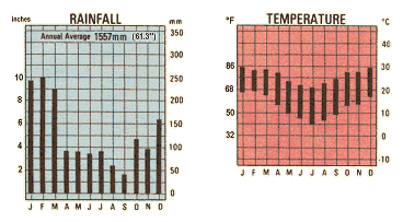
The mean yearly rainfall is 1687mm (66.4"), with most of this falling from mid December through to mid April, but heavy rain can fall at any time of year.
Dress
Dress is mostly informal and casual, with lightweight clothing suitable most of the year. Business attire is usually more relaxed, with trousers or dress slacks/shorts, and an open collar common for men, except on the most formal occassions. (If you're wearing a tie, you'll likely be tagged as a city slicker.)
Google Ads
It's advisable to bring clothing and broken in walking shoes that are comfortable, a hat* or two - although who will be able to resist buying a practical Aussie souvenir in this line?, swimwear (swimmers, cossies, togs, speedos, boardies, budgie smugglers), your favourite sunglasses and sunscreen*.
Include suitable attire for cooler and "wet" seasons, and bring some "glad rags" for the more formal night out, although most venues accept a good standard of resort wear.
Registered clubs, including surf lifesaving clubs located on beachfront, and sports clubs offering evening dining and entertainment, will generally request members and guests adhere to a minimum standard dress code; with no bare feet, no thongs (jandals, flip flops), no shorts, no bare chests permitted.
For those who plan to do some walking or field trips, a light backpack for snacks, drinks container (minimum 1 litre), natural insect repellent and 50+ sunscreen*, plus maps, compass and field guides, are standard. Don't forget your camera and binoculars!
* These items are readily available at most supermarkets, minimarts or outdoor stores in major towns, and general stores in villages.
Local Government Areas (LGAs)
Local Government areas (LGAs) which cover the area of the bigvolcano.com.au.au web site and beyond, include Ballina Shire Council, Scenic Rim Regional Council in Beaudesert, Richmond Valley Council in Casino, Kyogle Council, Lismore City Council, Tweed Shire Council in Murwillumbah and Byron Shire Council in Mullumbimby.
State and federal electorates include; State: Tweed, Lismore and Ballina in NSW; Currumbin, Burleigh, Gaven, Theodore, Scenic Rim, and Mudgeeraba in QLD.
Federal lower house seats are Page NSW and Richmond NSW, and Forde, McPherson and Wright, in QLD.
Towns
Major towns and larger population centres include the southern Gold Coast suburb of Coolangatta and its northern NSW twin town Tweed Heads, the university town of Lismore, the seaside resort towns of Ballina, Brunswick Heads, and Byron Bay, and the inland agricultural and farming centres of Casino (Cassino), Kyogle, Murwillumbah, and Alstonville on the southern plateau.
Domestic airports are located at Lismore and Ballina, with international flights from selected countries also flying into Coolangatta. Extensive retail outlets, professional and commercial servies, light industrial and trades estates are also found in most major centres.
Villages
Well known villages and smaller hamlets include Chillingham, Uki, the Gold Coast hinterland locality of Springbrook and Mt Tamborine plateau further north.
Cudgera Creek at Hastings Point, Photo © by J Palmer, Big Volcano Tourism
Beyond the coastal fringe to the west, the "Alternative Capital of Australia" - Nimbin, and the "Aussie bush" experience awaits the explorer in the countryside settlements epitomised by Woodenbong and Urbenville.
Most will have at least a general store (usually with basic Australia Post services), a garage and a pub.
Larger villages and beachside communities like Hastings Point, Cabarita Beach and Pottsville Beach are usually more developed than their rural counterparts, with a wider range of retail, professional and trade services available.
>> Next: About this Region - Getting Here
References and Readings
- Regional satellite image © courtesy of GeoScience Australia
- Temperature and Rainfall graphics, for Brisbane, from the map "Australia for Adventurers and Dreamers", Issue 18, April-June 1990, by the Australian Geographic Catographic Division
- HOTTEST YEAR: Weather records broken on the Northern Rivers 11th Jan 2018, Retrieved 18/07/18
- What climate change means for the Northern Rivers 5th Oct 2013, Retrieved 18/07/18
- CSIRO WARNS: Up to 3.7°C hotter and up to 25% drier 29/08/2017, Retrieved 18/07/18
- YouTube video "An Introduction to the Parliament of NSW", NSWParliament.
- YouTube video "4 Days in the NSW Northern Rivers and Coastal Region", HotelsCombined.
![]()
Google Ads
Booking.com