Big Volcano® Visitor Guide
Human History of the Northern Rivers - Gold Coast region New South Wales and Queensland, Australia, including Aboriginal stories, European discovery and settlement.
Human History

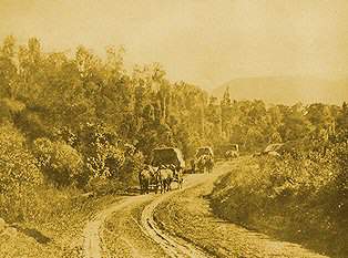
Photos © courtesy of Tweed Regional Museum - Murwillumbah,
Convoy Tyalgum Road, Bullock team Uki, Murwillumbah bridge
Big Volcano - Human History Index
For many thousands of years, the Bundjalung people enjoyed a warm sub-tropical climate. The landscape varied from towering mountains to the bountiful sea, providing an abundance of food and materials that met all their needs.
Written into European history in 1770, and named Mt Warning by Lieutentant James Cook, as a warning to other seafarers, the mountain reaching 1100 metres above sea level, is a regional icon to both indigenous peoples and later arrivals.
The "First Settlers" arrived in the region after a survey in 1828 by Captain Henry Rous, in command of the HMAS Rainbow. Cedar getters came first, searching for the prized Red cedar, and clearing the land for the dairy farmers, sugar cane, bananas, and other crop growers who took up their "first selections", from the 1840s onward.
While sugar cane, dairying and cattle remain agricultural mainstays, "Tree changers" and "Sea changers", arriving from the late 1970s onward, revived often sleepy villages and brought new energy to the region.
Human History
- The First Australians "Prior to 1788, Aborigines occupied all of mainland Australia and most of the inhabitable islands near the coast, including Tasmania."
- Tweed History. "Our Aboriginal oral tradition tells a story of 'Three Brothers' who came to this land and its people in the 'Dreaming', gave the lore, and formed the nucleus of tribes with whom today's traditional custodian descendants identify."
- Minjungbal Museum and Cultural Centre "For many thousands of years, the Tweed Valley was a green paradise resting in the shadow of the majestic Wollumbin."
- European Discovery: "Cook noted in his log on May 15th that "a tolerably high point of land bore N.W. by W., 3 miles distant; this point I have named Cape Byron. It may be known by a remarkable sharp peaked mountain lying inland N.W. by W. from it. Inland is pretty high, but near the coast it is low"."
- Australian Whaling History "Whaling was Australia's first primary industry and Byron Bay was one of a number of whaling stations along the east coast."
- The First Settlers: Tomewin "Straddling the Queensland/New South Wales border about 20 kms inland from Point Danger and the twin towns of Tweed Heads and Coolangatta, the European history of the Tomewin region dates from the mid 19th century."
- The First Settlers: Wooyung "For thousands of years Wooyung was a party place for Australia's original inhabitants. Nature supplied a bounteous feast of fish, pippies, roots, nuts and fruit in this spot."
- Dreamtime Stories: "The Nganduwal people have many Dreamtime stories handed through the generations, with more than one legend attached to Wollumbin / Wullumbini Momoli, and how its name came to be."
- The Walk of Remembrance and Centaur Memorial is located on the headland at Point Danger, and honours the ships and the brave men and women who gave up their lives for Australia.
- Museums, Historic Places and Heritage Buildings Museums, heritage sites and historical places include Aboriginal and European sites.
- Feature stories about the region; from the story of the Lions Road Scenic Link, though to the tales about flora and fauna, the history of local attractions, and more.
Towns and Villages
- Big Volcano Towns and Villages: A clickable geographical image map (85kb) of the region, with links to descriptions of the major towns and villages of the region.
- Towns and Villages: A directory of 14 major towns and 11 primary villages of the Big Volcano, with brief descriptions, and links to more comprehensive information about each settlement.
- Major Towns:
- Ballina Located at the mouth of the Richmond River, at the southern end of the Big Volcano, Ballina's name is originally from an aboriginal word meaning "place of many oysters".
- Byron Bay Cape Byron and its famous lighthouse is as far east as you can walk in mainland Australia. Steady growth in tourism infrastructure over the years, has made it possible for Byron Bay to provide "surf to rainforest" experiences to suit all budgets.
- Casino Strategically located at the junction of the Bruxner Highway and Summerland Way and sitting astride the upper reaches of the Richmond River, Casino is also the rail and freight hub for the far north coast of New South Wales.
- Kyogle Known as the "Gateway to the Rainforests", the McPherson, Tweed and Richmond Ranges lie in three of the four compass points from the town. For visitors who take a road less travelled, a stopover here provides the opportunity to experience a "typical" country town.
- Lismore is the Northern Rivers university town, and heart of the Rainbow region, with a wide range of visitor accommodation, conference facilities and natural attractions.
- Murwillumbah Very much a traditional style agricultural centre, Murwillumbah is located nearly exactly in the middle of the Mt Warning caldera, with the nearby Mount Warning commanding almost every view.
- Tweed Heads Located at the mouth of the Tweed River, the Twin Towns - Tweed Heads (New South Wales) and Coolangatta (Queensland) share a main street that straddles the state border.
- Selected Villages:
- About this Region Visitor information for travellers, including location, climate, dress codes, Local Government areas, and more.
Google Ads
Visit us on: